SILVERLEAVES CONSERVATION ASSOCIATION
COASTAL PROCESSES STUDY The Silverleaves Coastal Processes Study prepared for the Department of Energy, Environment, and Climate Action (DEECA) by consultants FSC Range was released at a well-attended community meeting held at Berninneit on Friday 30 August. The report is available online with a community survey and consultation open until 27 September. Download the study here.
In summary, the western shoreline of Silverleaves has eroded about 77 metres since 1953. The groynes and other measures have affected the sand migration from the west entrance of Western Port Bay, past Erehwon Point, along Cowes East to Silverleaves and out to Cowes bank. The report theorises a cause for the hotspot erosion at Sanders Road beach is the smooth design of the new nearby 2022 Cowes east rock walls, as well as the associated “relatively inefficient” groynes that “reduce the amount of sand available further downstream.” The report also states terminal erosion at the eastern most revetment that was constructed in 1977 has led in the decades since its construction to erosion, scouring, and reorientation of the shoreline at Silverleaves. “Erosion appears to have accelerated after construction of the revetment in 1977 and removal of the groyne field in this area sometime between 1985 and 1989.” Furthermore, analysis indicates “upstream revetments and previous timber seawalls have contributed to scour in the nearshore area” and “that historic sand scraping (bulldozing) may also be a contributing factor”.
It states “Recent beach nourishment efforts have proven to be sacrificial and are not considered a sustainable longterm solution for mitigating this erosion. “Further analysis indicates that existing interventions like groynes, while preserving beach amenity and retaining sand locally at East Cowes, impedes natural sediment supply to downstream areas such as Silverleaves”. The report notes that the recent acceleration at Silverleaves is due to groynes at Cowes East not being filled with appropriate grade of sand/sediment upon construction and after each storm event that empties them. The wall that was built should not have used smooth rock as this enhances wave action and increases sand migrating offshore to Cowes bank or further down towards Rhyll. The report recommends that groynes at Cowes east should be filled each time they are emptied, and the wall be modified.
Page 1. The report suggests sea level rise is coming faster than previously predicted, with the foreshore erosion assessment results indicating that at Silverleaves, significant loss of coastal reserve, private property, and public assets is possible within the next decade if nothing is done to stop it. The report concludes that by 2050 all frontline homes along Silverleaves may be submerged and by 2100 homes in about 150 metres from the current shoreline could have been breached. If the rate of erosion continues, the projections are grim. The report does not give immediate solutions, except to say that there should be planned adaptation. Even if action is agreed upon, it seems there is no budget allocation at local, state or federal levels, with no precedent for funding to protect private property.
The next step is to investigate short term protection actions, which might include further sand nourishment (bulldozing sand) to the groyne fields. Medium to long term the report recommendations are to develop sustainable, long-term adaptation pathway and coastal management strategies beyond sacrificial beach nourishment efforts. According to the Marine and Coastal Policy, adaptation solutions are: (1) nonintervention, allowing marine processes to occur; (2) avoid locating new developments; (3) natural methods such as vegetation; (4) accommodating changes such as building for impact of flooding; (5) retreat away; and (6) protect through physical barriers. Click here to go to the Marine Costal Policy.
Community consultation on the Coastal Processes Study report is now open and the SCA encourages you to complete the survey which closes at on 27 September 2024. Click here to take the survey. The findings will be presented in November and an “adaption pathways” report released in February 2025. Community consultation on this report is then expected to run in March and April 2025. In May the findings from the community consultation will be released, before a final adaptation plan is released in July 2025.
This raises a number of concerns for Silverleaves residents as we can expect inundation due to rising sea levels in the next 25 years from both the foreshore and the Rhyll inlet. Do we continue to build structures to protect the environment and home, how much will this cost and who will pay for it? How do we improve the resilience of the foreshore, which could include suitable revegetation works to retain sand? Should further housing development be halted because of the future risks? And what does this mean for the value of our properties? Or are we facing a worst-case scenario in the future of retreat and advocate for government buy backs? We face an uncertain future and the Silverleaves we know, and love is changing.
WHAT CAN YOU DO ABOUT EROSION
- Stay away from erosion areas and eroded sand cliff faces as this can cause further damage.
- Use the designated beach access tracks and avoid using small beach tracks in front of foreshore properties. These tracks make the sand more vulnerable to further erosion.
- Protect the foreshore vegetation as it plays an important role in stabilising the sand dunes, tree roots and grasses make the sand more stable. The foreshore is home to wildlife and birdlife and protects properties from the elements.
- Consider joining the ongoing work by the SCA working bees revegetating the foreshore and do your bit by planting a tree.
-Spread the word, talk to your neighbours and visitors about the importance or preserving the Silverleaves foreshore for the future.
Bass Coast Shire manage all foreshore reserves and if you notice any clearing of vegetation to gain a view or path notify the Bass Coast Shire 1300 BCOAST (226 278)
Sand Renourishment Works
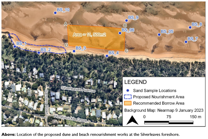
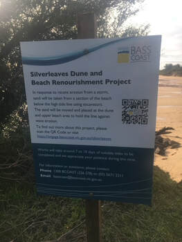
SCA received an email advising that sand renourishment works were commencing on Monday 21 August for 7-10 days. Sand will be scraped from the “intertidal borrow area” which is between the Sanders Road beach path and the next beach path to the east. The sand will be moved to the dune and upper beach area around Sanders Road beach path and to the west along the dune /foreshore line to the rocks. See the image below:
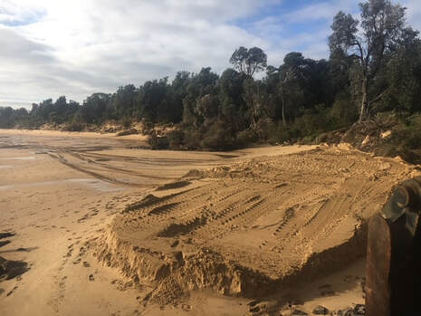
Sand Works Have Started
Your browser does not support viewing this document. Click here to download the document.